| §3. Illustration of earthquakes and tsunami in 1854, Osaka. |
| 3.1.Igaueno Earthquake (June 14th in the 7th year of Kaei period [July 9th, 1854]) |
In Osaka people did not suffer from this earthquake. According to another document, 'The Record of the Earthquake in the 6th Year of Kaei Period' *2, many people in Osaka were frightened by the shaking and fled into ships on the canals. They thought that the canals were the safest place to be in Osaka City. This time people were lucky not to have met with a tsunami because the epicenter of this earthquake was inland..
| 3.2.Ansei Tokai Earthquake (December 23rd, 1854) |
| 3.3.Ansei Nankai Earthquake (December 24th , 1854) |
| 3.4 . Ansei Nankai Earthquake Tsunami |
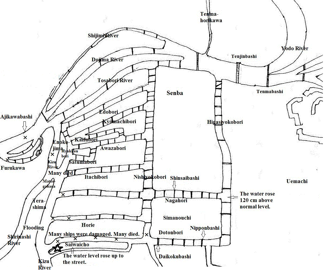
The tsunami came in through the two mouths of the Yodo River and ran upstream, and muddy water reached the east end of the canal, the Higashiyokobori River, where the water level was 120cm higher than usual ('Daijishin Ryo Kawaguchi Tsunamiki'). (Fig. 4)
I researched how long it would have taken for the tsunami to reach Osaka Bay after the Ansei Nankai earthquake occurred.
After examining 26 documents, I calculated that it took from one hour 22 minutes 30 seconds to one hour 50 minutes. People were frightened by the violent shaking and chose to escape into boats on the canals. They did not think of the tsunami that would hit Osaka after a big earthquake.
| 3.5. Damage caused by the Ansei Nankai Earthquake Tsunami. |
3.5.1. Ships
According to 'Naniwa no Shinji' ('The Record of Earthquakes in Naniwa'*5) , the ships anchored at the two mouths of the Yodo River (Kizugawaguchi and Ajigawaguchi) were suddenly carried up into the canals of Osaka by a big tsunami. There were 1,118 of these vessels, 59.2% of which (662) were severely damaged.
By river:
370 ships in the Kizu River (including the Hyakkenbori, Nagahori and Itachibori Rivers)
163 ships in the Dotonbori River
129 ships in the Aji River
662 total.
According to the document 'Kinrai Nendaiki', 80% of the severely damaged ships were carried from the mouth of the Kizu River.
"High waves washed over Maedarejima[Island]and Nanbajima [Island]. All of the large and small ships resting on these islands were carried up the Dotonbori River. Large ships collided, causing the collapse of four bridges, crushing many small ships and finally stopping at the Daikokubashi [bridge]." (Fig. 4)
The inscription describes it as follows:
"West of the Daikokubasi[bridge]and from north to south of Matsugahana, a mountain of ships covered the surface of the rivers; most of the ships were damaged".
The tsunami hit in early November on the lunar calendar (Dec.24th on the Gregorian calendar). It was in winter, cargo ships (called Kitamae Bune) used for transport to the northern parts of Japan in warmer months were docked at the Sangenya River for repair. The inscription reads: "In winter, ships resting for repair should be pulled as high as possible."
3.5.2. Bridge
The tsunami carried many large cargo ships up the rivers. These ships collided with and destroyed many bridges.
The inscription says "Ten bridges were destroyed." However, the documents 'Naniwa no Shinj' and 'Osaka Kawaguchi Ohtsunami konzatsuki' *6 indicates that the Kunitsubashi was also destroyed. So, in total eleven bridges were destroyed. (Table 1) (Fig, 4)
Table 1. Destroyed bridges, by river.
| River | Destroyed Bridge | |
| Aji River | Ajikawabashi | 1 |
| Furukawa River | Kunitsubashi | 1 |
| Kizu River | Kameibashi | 1 |
| Nagahori River | Takahashi | 1 |
| Horie Rive | Mizuwakebashi, Kuroganebashi (Tetsuhashi) | 2 |
| Dotonbiri River | Hiyoshibashi, Shiomibashi, Saiwaibashi, Sumiyosibasi | 4 |
| Nishiyokobori River | Kanayabashi | 1 |
| Total | 11 | |
3.5.3. Houses and Sheds
In Osaka, most of the damage to buildings was caused by large ships that smashed into buildings along the rivers. The inscription reads:
"The sheds by the rivers were crushed by the big ships with crushing sounds and the sounds of people's cries. There was nothing that could be done to stop this sudden tragedy.'The Kinrai Nendaiki' said:
"The houses, warehouses, and sheds on the riversides were crushed by the big ships. Ships' bows pierced the walls of the buildings. These ships could not go down the river after the tsunami"
According to 'Ofure and Kudatsu *7' ('Official Notice and Verbal Notification'), the numbers of damaged houses by the tsunami in Osaka City were as follows.
| Collapsed houses: | 3 |
| Seriously damaged houses: | 76 |
| Collapsed sheds: | 8 |
3.5.4. Fatalities
In Osaka City there were only 2 fatalities (among people registered as inhabitants of Osaka City *8) as a result of the Ansei Tokai earthquake and the Ansei Nankai earthquake. This was relatively few people. The fatalities as a result of the tsunami were great. The numbers of deaths as recorded in various documents are quite different.
| ['Ofure and Kudatsu'] | 273 people (registered as inhabitants of Osaka City) |
| ['Syokisai hibizakki'] | 2600 people |
| ['Suzukidaizassyu' ('Suzuki's big miscellany')] *9 | 7000 people |
'The Kinrai nendaiki' says:
"Five or ten corpses were pulled out at a time; 200 to 300 corpses were pulled out every day. All had to be investigated and most of them had been living in Saiwaicho or Nanbajima or had been sailors. There was a mountain of funerals and corpses had been burning day and night. After five or six days passed the number of corpses gradually began to diminish to five or ten a day. However, when the large ships were removed, corpses began to be pulled out again. This work took more than ten days to finish."
According to this document the number can be guessed to be over one thousand.
'Matsudai hikae'('Notes for future generations')*10wrote:
" It was most pitiful that people were so afraid of the preceding day's and that day's earthquakes: people in town, young and old, women and men, rich and poor all lost their heads, cried out, and fled into ships. No sooner had they felt relief when the big tsunami rushed in. They fell into the river. Their cries sounded throughout Osaka. It was so pitiful. We could not even look at the sight."
The reason that so many people fled into boats.
According to Saichiro Isedo *11, the streets in Osaka were very narrow, because the merchants built long eaves out toward the streets. Usually the canals had been safe, sound open spaces. In Osaka many big fires often occurred; people loaded their property into boats and fled.
The inscription reads:
"Always be careful of a tsunami after a big earthquake occurs and do not seek refuge in boats."
3.5.5. Flooded areas.
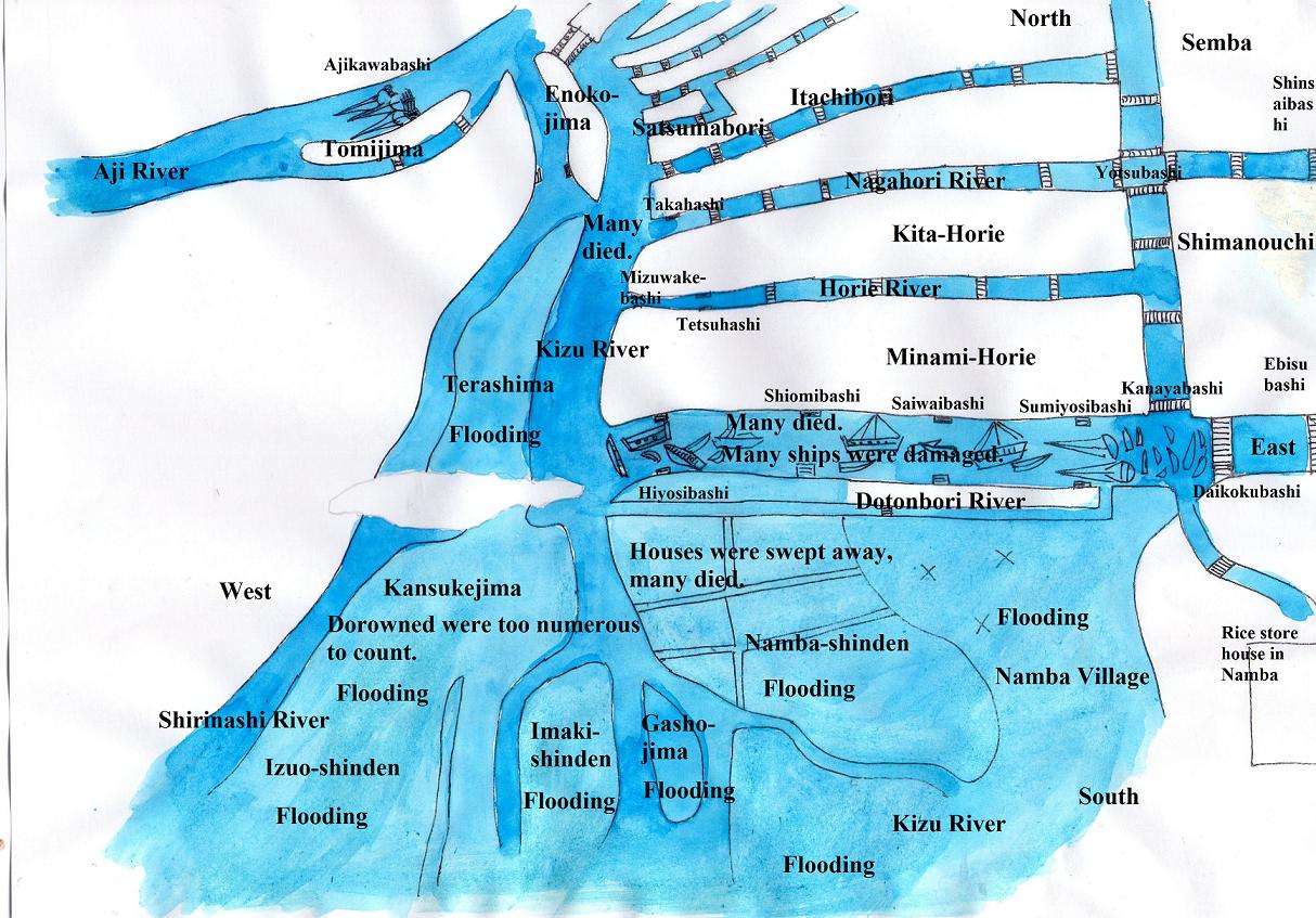
At about 9:00am, Nov. 4th, 1854, a big earthquake occurred. In Osaka, many houses were damaged. On the next day (the 5th ), earthquakes occurred frequently, in the evening, a tsunami suddenly hit; large ships anchored at the mouths of the Aji and Kizu Rivers were carried upstream, smashing into and destroying bridges. Many ships were carried from the mouth of the Kizu River to Daikoku-bridge, and from the mouth of the Aji River to Ajikawa-bridge. The ships were too numerous to count. The dead and injured were great number. It is a pity; we could not watch them. Drowned were too numerous to count in Kansukejima. Terashima, Imaki-shinden, Gasshojima, Kizu and Namba were flooded; it looked like a sea. It's really an unprecedented occurrence. We recorded details on this map.
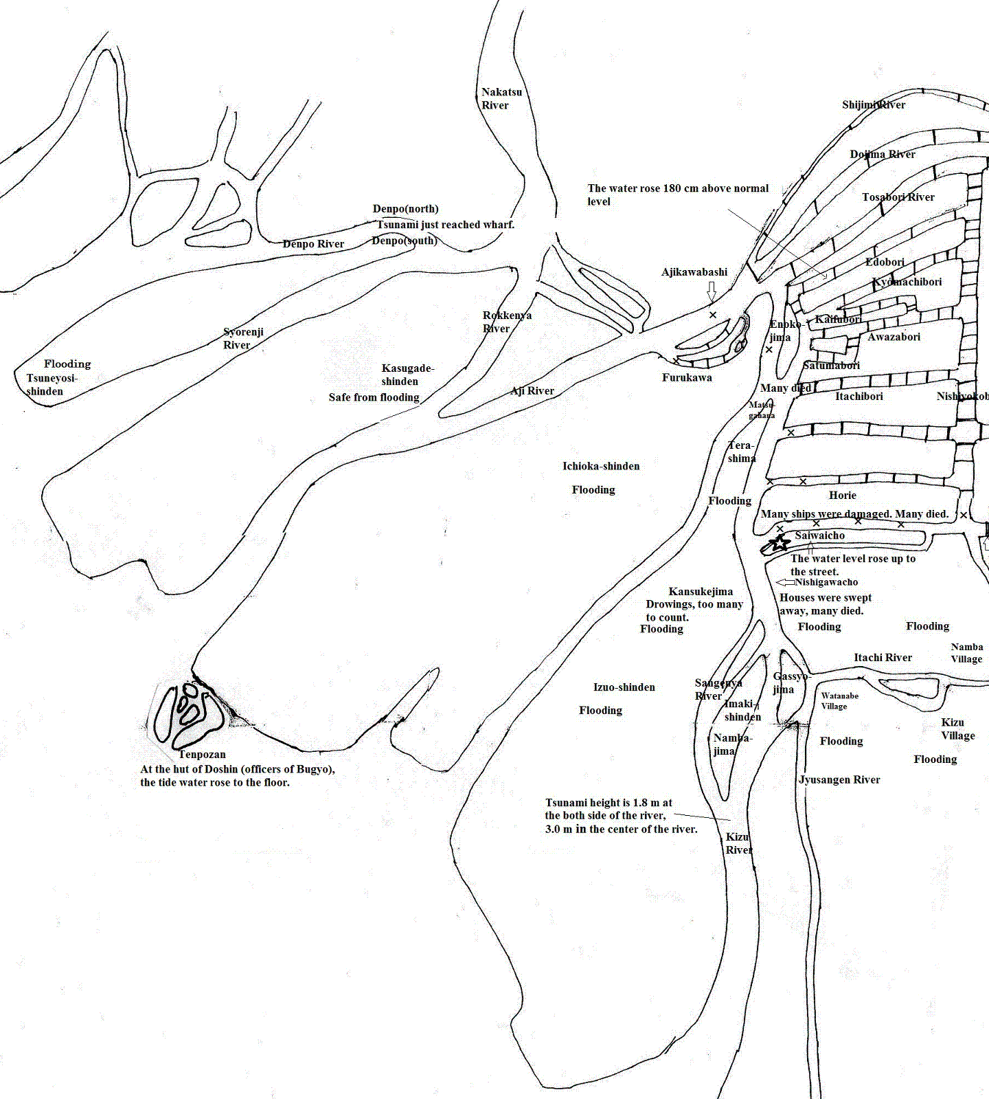
Based on 'The Map of a Big Tsunami in Osaka' (the original of which is in Osaka Castle), we estimated the flooded area.
(1)The areas flooded, In Osaka City. (Fig.5, 6)
・Saiwaicho (the town along the Dotonbori River).
・The north part of Terashima (the island in the Kizu River)
We estimate the depth of inundation in these areas to have been no more than 30 cm. We do not find any other inundated area on the map. According to the document 'Naniwanoshinji'('The Record of Earthquakes in Naniwa'), the tsunami did not cause flooding in Osaka City.
The document records a very strange phenomenon: The tsunami waves were so high that they carried big ships up the river swiftly, although the water only reached the surface of roads in the city's lowest places, and at the higher places did not exceed even half the height of the banks. This document says that serious flooding did not occur in Osaka City.
(2)The areas flooded , Outside Osaka City. (Fig.5, 6)
・Kansukejima (island), Izuoshinden (reclaimed land) and Imakishinden (reclaimed land)・・・Now, Taisho ward.
・Gasshojima (island), Kizu village, Namba village・・・Now, Naniwa ward.
These districts are along the Kizu River.
These flooded areas are now the north of Taisho ward and the west of Naniwa ward. In these areas, which were outside of Osaka City, people who climbed onto roofs were safe and those who fled into boats died.
・Tenpozan (now Minato Ward in Osaka City)
Tenpozan belongs to Osaka-sango(Osaka City), but Tenpozan was far from the centre of Osaka City, so for convenience's sake, we place Tenpozan outside of Osaka City.
'The Map of a Big Tsunami in Osaka', does not include Tenpozan, which is outside of the map. However two documents record Tenpozan as an inundated area and include the depth of inundation.
According to 'The letter from Yamamotoya Iemon and Kantaro' *12, "At the hut of both Bugyo (East Bugyo, west Bugyo), the tide water rose to 15 cm under the floor". The people who climbed Mt. Tenpozan were safe.
Another document 'Shokisai hibizakki' stated; "At the hut of Doshin (officers of Bugyo), the tide water rose to the floor". (Fig. 6)
・In the area north of the Aji River.
We did not find any documents recording the inundation in the area north of the Aji River.
According to 'The Letter from Osaka'*13, the northern area was not damaged, and Kasugade-shinden was safe.
However, I presume that Tsuneyoshi-shinden situated at the north of the Aji River would have been seriously inundated, because there is a memorial*14 inscribed " grave for those drowned in a Kaisho[a word meaning both "tsunami" and "high tide" ]in the third year of Ansei". Referring to the history of Osaka, we can't find a flood in the third year of Ansei. So, it is thought that the inscription is wrong, and it was in fact the first year of Ansei.
3.5.6. The phenomenon of the liquefaction.
The inscription reads:
"Tsunamis rush in not only from offshore but also from the bottom of the shallows along the shore. A lot of muddy water sprang up from the reclaimed land along the shore."
This phenomenon is called " liquefaction of the ground." It is actually caused by the earthquake, and is not related to the tsunami. When a big earthquake occurred in Niigata prefecture in 1964, muddy water sprang up from the reclaimed land and wet land along the Shinano and the Agano Rivers. Modern structures such as the Showa Bridge collapsed, and new concrete apartments were laid flat. One of the safety myths also collapsed in this disaster. Scientists and architects had never been aware of this phenomenon before the Niigata earthquake (1964A.D.). They started to seriously consider countermeasures against liquefaction of the ground. But this phenomenon was already described in old documents.
*1 [Usami, T.(2003)]
*2 [Kuroha, H. (1979)], The 6th Year of Kaei Period is an error on the part of the document's writer; it was actually the 7th year.
*3 [Kuroha, H. (1979)]
*4 [Kuroha, H. (1979)]
*5 [Kuroha, H. (1979)]
*6 The original is in Osaka Prefectural Nakanoshima Library.
*7 [Kuroha, H. (1979)]
*8 In the Edo era Osaka City consisted of three wards(Northern ,Southern and Tenma)
*9 [Kuroha, H. (1979)]
*10 [Kuroha, H. (1979)]
*11 [Isedo, S. (1983)]
*12 [Musha, K. (1951)]
*13 [Earthquake Research Institute Of The University of Tokyo(1986)]
*14 There is a stone memorial at 5 chome, Torishima in Konohana Ward, Osaka City. It situated along the bank of the New Yodo River.


